Select language
Sprache auswählen
Take the bus to the starting point of Östgötaleden trail - when staying at Vårdnäs
We at Vårdnäs protect the environment in many ways. One is that we like to see our guests take the bus to the starting point for their hike on Östgötaleden / Rängen Runt. We are lucky to have a bus that stops relatively close to Vårdnäs Stiftsgård and which makes available many starting places along the trail!
Take bus 566 to Vårdnäs
We recommend our hikers to start their hike by taking a bus to the starting point, and then without stress hike back to Vårdnäs. It is of course possible to do the opposite - to start your hike at Vårdnäs and take the bus back. But then there is a time to fit. Bus 566 is a bus route in the countryside and therefore has less traffic than a bus in a city, so you don't want to miss the bus... Then the only option is a taxi or walking back again...
Not all places in the countryside have local bus services, but Vårdnäs Stiftsgård is happy that we have a bus line with a stop 1.3 kilometers from Vårdnäs Stiftsgård. The bus stop is called "Vårdnäs vägkors". Expect a 20-minute walk and you'll catch the bus in time. Here is a link to Östgötatrafiken's collection page with information about bus 566. (site in swedish).
Buying a bus ticket
You can easily buy a bus ticket on the bus using a payment card or with the "Östgötatrafiken" app. Read more about buying a ticket on Östgötatrafiken's website. (site in swedish).
Bus stops where you can start your hike
There are several possible starting points on Östgötaleden where bus 566 stops nearby. So perfect to get on the bus at the Vårdnäs crossroads and then take it to the bus stop where you want to start your hike.
- The bus stop closest to Vårdnäs Stiftsgård
Vårdnäs' closest bus stop is called "Vårdnäs vägkors". From the bus stop to Vårdnäs, it is 1.3 kilometers to walk. Expect a 20-minute walk.
- The bus stop in Bestorp (Sätravallen)
In Bestorp community there is a bus stop called "Bestorp". This is where you get off if you want to connect to Östgötaleden / Rängen Runt and start in Sätravallen. Östgötaleden is signposted from the bus stop to the trail in the vicinity of Sätravallen. The distance from the bus stop to the starting point in Sätravallen is about 3 kilometers and takes about 30 minutes to walk.
- The bus stop in Bjärka-Säby
In Bjärka Säby, the bus stops very close to the hiking trail. The bus stop is called "Bjärka Säby" Here it is only about 200 meters until you see the signs along the trail.
- The bus stop in Hamra lock (Östanskog location B)
The bus stop in Hamra is also close to the hiking trail. The stop is called "Östanskog location B". You should see the trail's signage on the other side of the road when you get off the bus.
- Bus to and from other places - Local traffic
Östgötatrafiken also offers a concept called "Närtrafiken". Then it is possible to order transport to certain places where regular public transport does not operate.
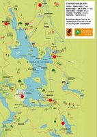
- Map with bus stops in area "Rängen Runt"
Click on the image to get to a map of the hiking trail and where bus stops are marked to see where the bus stops are in relation to the trail. Please note that there is no public transport on the west side of Lake Stora Rängen, only on the east side:
At the digital map at the webpage ostgotaleden.se you se all the bus stops marked.


